Starting point
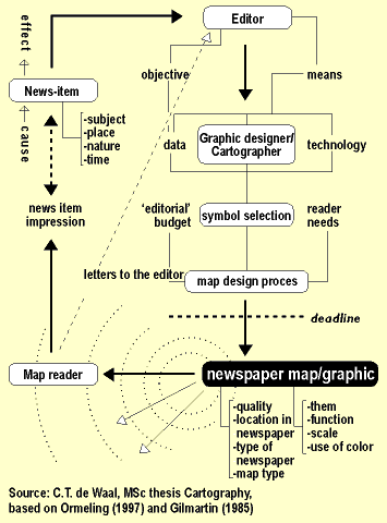
The model caters for the various attributes of newspaper maps, for feedback from the map user to the map editor, for various objectives, data categories, means and technology, symbol selection, catering for user needs and the restrictions of the editorial budget, both in money and time.
The hypotheses have been visualised in the matrix shown in figure 6a. In order to elucidate this matrix, I can show that it claims that all map themes have as an important function the locating of the news item. For a far smaller number of themes the maps have an explanatory function: for physical planning, politics, geopolitics and resources. A stimulating or decorative function was claimed only for tourist maps, while it were only the physical planning maps that were thought to have a recognition or logo function.
Finally it was claimed that there would be differences between national and regional newspapers in so far as the latter would contain more physical planning maps and more maps of accidents (Ormeling 1997). The developments reported on here further diversify the third postwar period of mass media development as discerned by Scharfe (1997).
These visual hypotheses were translated into texts as follows:
The general research issue was: What was the development in mass media map production in national newspapers in the Netherlands between 1988 and 1996?
Partial issues were:
1. How can these developments be described both quantitatively and qualitatively?
2. Is there a correlation between the newspaper map theme on the one hand and the map function, the newspaper section that contained the map and the newspaper map tyep on the other hand?
3. Is there a difference in characteristics between weekdays newspaper maps and those contained in newspapers in the weekend? And is there a difference in characteristics between coloured and black/white newspaper maps (apart from the use of colour itself)?
4. Has there been a geographical trend in the development of newspaper maps?
For the first issue the following attributes were researched: map theme, function, map type, location in the newspaper, use of colour, map scale, map quality, size and sources. For the map types we differentiated between for instance route maps, topical maps and planning maps; for the scale aspect, maps were grouped into local, regional, national and international scales. Regarding the quality the maps were checked for the proper visual hierarchy, symbol selection, functionality of the base map, added texts, relationship with the newspaper article, proper title, functionality of colour, and uniformity of style. For the sources we differentiated between cartographic news agencies, other cartographic producers and the newspaper itself.
For the second issue it was checked statistically whether the newspaper map themes correlated with the map functions, the map sections or the map types. For the third issue supposed differences between weekly and weekend maps were checked as were differences between coloured and black/white maps. For the fourth issue , the scales of the maps were studied.