How can the developments be described both quantitatively and qualitatively?
1. The total number of maps increased;
2. The percentage of colour maps increased;
3. Front page maps usually had one column width and were printed in two to four colours;
4. Front page maps usually related to politics, military conflicts and accidents;
5. Front page map sources usually were provided by external news agencies;
6. Maps in additional section usually were larger and more colourful than on inner pages of the first section;
7. Additional section maps usually stood on their own;
8. Newspaper maps were more frequently international than national, regional or local;
9. Quality newspapers had more home-produced maps than popular newspapers;
10. Popular newspapers had more crime maps than quality newspapers;
11. Quality newspapers have higher quality maps than popular newspapers.
These seem to be common sense statements, but even those need to be checked and proved.
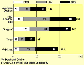
The first hypothesis was easy to check. Figure 2 shows the increase of the number of maps, and also shows that the major increase happened between 1988 and 1992.
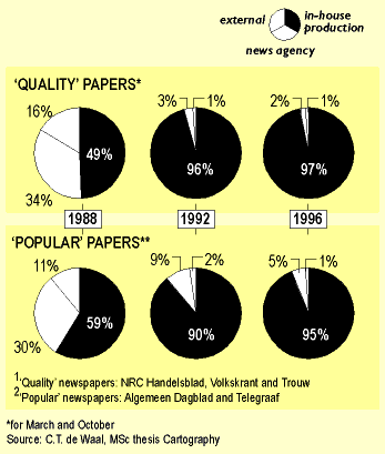
The number of colour maps increased likewise, stand alone maps increased and topical maps increased, both absolutely and relatively. Maps on the front page indeed were mostly one column in width and had colour as well. Military conflicts, geopolitics and accidents together accounted for 69% of the front page maps. Elsewhere, in the inner pages they accounted only for 39%, and in the additional sections only for 5%. The percentage of maps provided by external agencies only decreased during the researched period. See also table 1.
|
Front page
|
Inner pages
|
Additional sections
|
||||
|
66
|
92 %
|
440
|
88 %
|
338
|
89 %
|
|
|
5
|
7 %
|
50
|
10 %
|
15
|
4 %
|
|
|
1
|
1 %
|
8
|
2 %
|
22
|
6 %
|
Surprisingly, there has been a relative decrease in the number of international maps. This really means that newspaper maps got more widely accepted, and that for local and regional news the role of the map has been increasingly discovered. See also table 2.
|
1988
|
1992
|
1996
|
||||
|
17
|
9 %
|
36
|
10 %
|
65
|
16 %
|
|
|
44
|
24 %
|
93
|
27 %
|
137
|
33 %
|
|
|
43
|
23 %
|
99
|
28 %
|
85
|
21 %
|
|
|
80
|
44 %
|
120
|
35 %
|
126
|
31 %
|
|
(n=73) |
(n=105) |
(n=118) |
(n=50) |
(n=81) |
(n=427) |
|
|
1.5
|
1.7
|
1.3
|
1.5
|
1.6
|
1.5
|
|
|
1.4
|
1.8
|
1.3
|
1.4
|
1.7
|
1.5
|
|
|
1.0
|
1.2
|
1.0
|
1.2
|
0.9
|
1.0
|
|
|
1.6
|
1.8
|
1.7
|
1.9
|
1.9
|
1.8
|
|
|
1.6
|
1.7
|
1.7
|
1.4
|
1.7
|
1.6
|
|
|
0.8
|
1.0
|
0.4
|
0.4
|
1.1
|
0.7
|
|
|
1.0
|
1.1
|
1.0
|
1.1
|
1.0
|
1.0
|
|
|
0.8
|
1.5
|
0.8
|
1.5
|
1.2
|
1.2
|
|
|
9.7
|
11.8
|
9.2
|
8.9
|
11.1
|
10.3
|
the newspaper section that contained the map and the newspaper map type?