|
|
|
|
|
|
|
Is there a correlation between the newspaper map theme on the one hand and the map function, the newspaper section that contained the map and the newspaper map type?
|
|
|
|
|
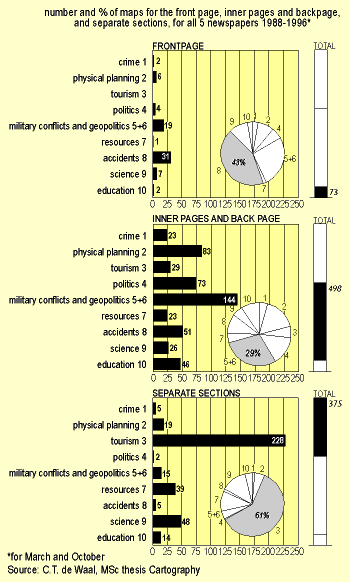
The second issue was, whether the newspaper map theme could be correlated to map function, newspaper section and map type. Figure 5 proves that this is indeed the case. The front page diagram shows that military conflicts and accidents together accounted for 70% of the maps; in the inner pages, military conflicts and geopolitics accounted for 29%, and in the additional sections, tourism maps accounted for 61! The latter almost had no accident maps at all, but scored relatively well in resources maps and science.
|
|
|
|
|
 |
|
|
|
|
|
Figure 5 - Newspaper map themes according to newspaper section where they were inserted |
|
|
It has all been brought together in the next pair of illustrations (figure 6), where the assumed correlations are compared to the actual one. Although there was not enough time to analyse the different newspaper types as well (only the quality aspect was taken into account) it can be seen that there was a large overlap between the two illustrations.
We will look at the map functions first. The explanatory map function postulated by Ormeling did only occur sparsely, although it increased over time. The logo function occurs most in political maps, such as produced from elections results. There is almost a complete overlap between the newspaper section parts. The newspaper type aspects cannot be compared.
|
|
|
|
|
 |
|
Figure 6 - Newspaper map themes compared to map functions, newspaper sections and type of newspaper, according to Ormeling (6a) and as found by DeWaal (6b) |
|
|
|
Is there a difference in characteristics between weekdays newspaper maps
and those contained in newspapers in the weekend?
|
|
|