| Konferenciákon, tanácskozásokon, tudományos intézményekben tartott tudományos, szakmai előadások |
| 2022. XII. 10. | A geoinformatika mesterszak elindítása | Térképészeti Tudományos Nap |
| 2022. IX. 24. | Exploring intentional distortions in Cold War era tourist maps (Zentai László-Hajdú Edina) | 16. Cartoheritage Conference, Kolozsvár, Románia |
| 2022. IX. 18. | Cold War era topographic maps: Soviet influences on Hungarian civil topographic maps | Eurocarto, Bécs, Ausztria |
| 2022. VI. 25. | A Perczel-glóbusz | Múzeumok éjszakája, ELTE Egyetemi Könyvtár |
| 2022. VI. 21. | Does cartometry still matter? | 8th International Conference on Cartography & GIS, Neszebár, Bulgária |
| 2021. XII. 17. | The effect of the Cold War era on maps for public use in the Eastern Bloc countries: Tourist maps (László Zentai and Gábor Gercsák) | 30th International Cartographic Conference, Firenze, Olaszország |
| 2021. XII. 17. | Maps of first orienteering events | 30th International Cartographic Conference, Firenze, Olaszország |
| 2021. XII. 16. | The new National Atlas of Hungary – volume Society (Gábor Gercsák, Károly Kocsis, Zsombor Nemerkényi, and László Zentai) | 30th International Cartographic Conference, Firenze, Olaszország |
| 2021. XII. 16. | A multicity investigation on Fear of Crime (Andrea Pődör, László Zentai, and Zalán Hum) | 30th International Cartographic Conference, Firenze, Olaszország |
| 2021. XII. 15. | The Perczel Project (2007–2019) (Mátyás Márton, Gábor Gercsák, and László Zentai) | 30th International Cartographic Conference, Firenze, Olaszország |
| 2021. XII. 15. | A new interactive gazetteer of Perczel’s globe (Zsuzsanna Ungvári, Gábor Gercsák, Mátyás Márton, and László Zentai) | 30th International Cartographic Conference, Firenze, Olaszország |
| 2021. X. 28. | Versatile, Open-Minded and Supportive | Pre-ICC2021 CET online workshop (on-line) |
| 2021. VI. 11. | Összefoglaló az agrárinformatikai témacsoport tevékenységéről | Tématerületi Kiválósági workshop (on-line) |
| 2020. XII. 11.. | Györffy György kartográfiai munkássága (Györffy János társszerzővel) | Térképészeti Tudományos Nap, 2020 (on-line) |
| 2020. XII. 11. | A Perczel-glóbusz újjászületése (Márton Mátyás társszerzővel) | Térképészeti Tudományos Nap, 2020 (on-line) |
| 2020. IX. 21. | From the digital contentual facsimile of a globe map to a contemporaneous facsimile globe in 3D (The rebirth of Perczel’s globe) - társszerzők: Márton Mátyás-Zentai László-Gercsák Gábor | EuroCarto, Vienna (on-line) |
| 2020. V. 8. | Results in the Research Group Agroinformatics | ELTE, Faculty of Informatics, Neumann-nap |
| 2020. II. 16. | Különböző országok tájfutótérkép-nyilvántartásai | Térképfórum 2020, Budapest |
| 2019. XI. 12. | Promote the Use of EO/GI Data and Support the Related Ecosystem Development for Sustainable SDGs (társszerzők: Remetey-Fülöpp G, Mihály Sz, Palya T, Hargitai P, Iván Gy) | 2. Symposium „Neue Perspektiven der Erdbeobachtung“, Köln, Németország |
| 2019. IX. 24. | Unlock and Use EO/Geospatial Data for SDG by Empowering Stakeholder Engagement in a Transformed Society (társszerzők: Remetey-Fülöpp G, Mihály Sz, Palya T, Hargitai P, Iván Gy) | 11th International Symposium on Digital Earth, Firenze, Olaszország |
| 2019. VII. 17. | Digital sketch maps in teaching GIS for law enforcement students (társszerzők: Andrea Pődör, Erika Gál) | 29th International Cartographic Conference, Tokió, Japán |
| 2019. VII. 17. | Cross-border topographic mapping, cross-border orienteering: the Hungarian overview (társszerző: Gábor Gercsák) | 29th International Cartographic Conference, Tokió, Japán |
| 2019. VII. 16. | The new National Atlas of Hungary – volume Natural Environment (társszerzők: Károly Kocsis, Zsombor Nemerkényi, Gábor Gercsák) | 29th International Cartographic Conference, Tokió, Japán |
| 2019. VII. 12. | Teaching orienteering maps: a perfect example of for user-driven cartography | International Workshop on Geospatial and Cartographic Education – Contemporary Challenges and Opportunities 2019, Peking, Kína |
| 2019. VII. 11. | Experiences of a new English language MSc programme in cartography (társszerző: Gercsák Gábor) | International Workshop on Geospatial and Cartographic Education – Contemporary Challenges and Opportunities 2019, Peking, Kína |
| 2019. V. 8. | Preservation of national atlases | 14th Conference Digital Approaches to Cartographic Heritage, Szaloniki |
| 2019. III. 19. | Száz év térképészet | A magyar katonai térképészet 100 éve 1919–2019 könyv bemutatója, Budapest |
| 2018. X. 31. | Modern cartography – ICA's view | 15th Hellenic Cartographic Conference, Thesszaloniki, Görögország |
| 2018. X. 16. | Hungarian GIS Data for the Sustainable Development Goals (társszerzők: Tamás PALYA – Szabolcs MIHÁLY – Gábor REMETEY-FÜLÖPP) | European Forum for Geography and Statistics, Helsinki |
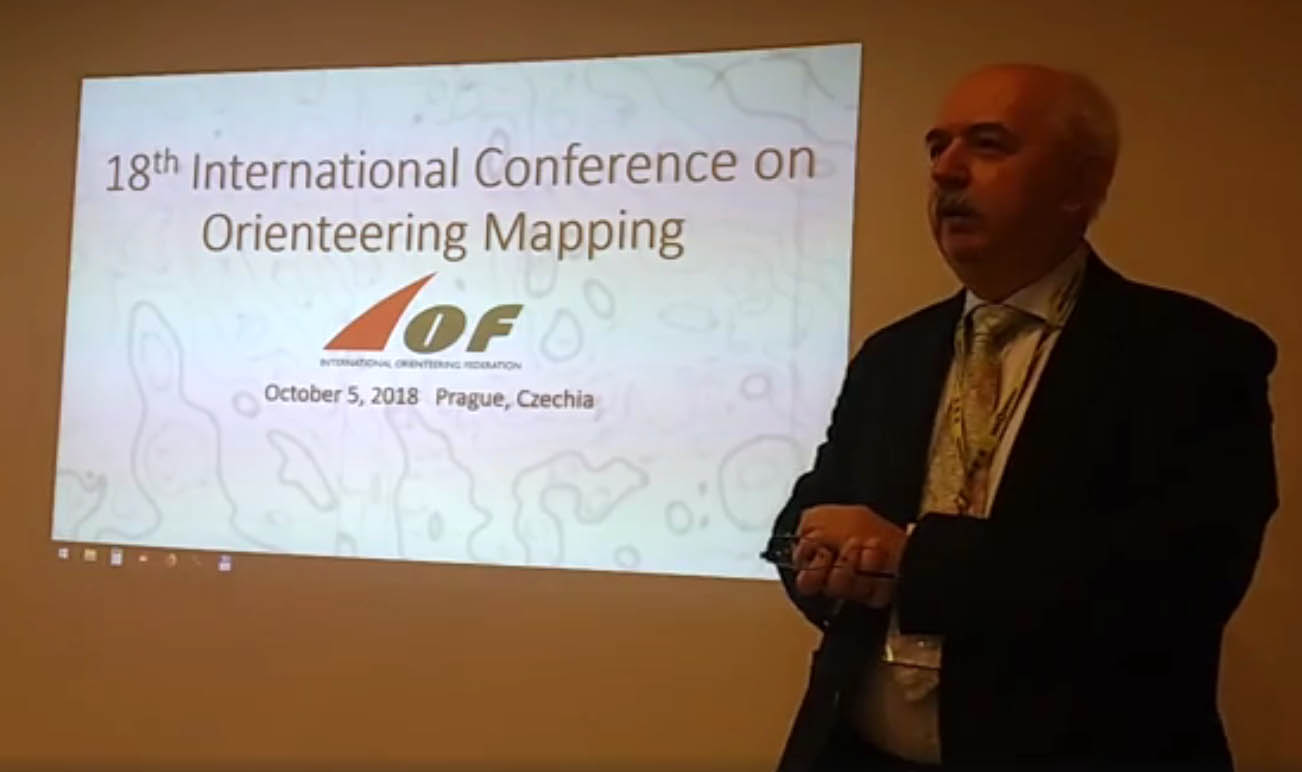
| 2018. X. 5. | Orienteering and cartography | 17th International Conference on Orienteering Mapping, Prága, Csehország (videó) |
| 2018. IX. 27. | SDI and ICA | SDI days and 14th International Conference on Geoinformation and Cartography, Zágráb, Horvátország |
| 2018. VIII. 27. | Orienteering maps in cartography | Annual Conference of the Japan Cartographers Association, Toyama, Japán |
| 2018. VI. 20. | ISOM2017: The new specification of orienteering maps (an insight) | 7th International Conference on Cartography & GIS, Szozopol, Bulgária |
| 2018. VI. 20. | A Hungarian on-line map service based on GIS data and visualised by cartographic approach (társszerző: Nyőgéri Gábor) | 7th International Conference on Cartography & GIS, Szozopol, Bulgária |
| 2018. VI. 20. | Geospatial data and services to support the UN Agenda 2030 implementation: Hungarian Activities (társszerzők: Mihály Szabolcs, Remetey-Fülöpp Gábor, Palya Tamás) | 7th International Conference on Cartography & GIS, Szozopol, Bulgária |
| 2018. IV. 27. | Development of Hungarian school atlases in the last decades | ICA Commissions Joint Workshop on Atlases, Cognition, Usability, Olomouc |
| 2018. IV. 18. | Case Study on the Connection of Digital Humanities and Cartography: Hungarian place-names in English language maps | 13th ICA Conference on Digital Approaches to Cartographic Heritage, Madrid |
| 2018. III. 21. | Egyetemi Digitális Térképtár, az egyetemi oktatás támogatásának eszköze | Földmérők Világnapja - Európai Földmérők és Geoinformatikusok Napja, Budapest |
| 2017. XII. 3. | ICA contribution to atlas production and Hungarian experiences | Un Atelier International sur l'Élaboration de l'Atlas Scolaire Algérien, Algír |
| 2017. VII. 5. | Educational aspects of crowdsourced noise mapping (Pődör Andrea társszerzővel) | 28th International Cartographic Conference, Washington DC |
| 2017. VII. 5. | Adventures of a world atlas – History of the publication of the Debes Atlas in Hungary (Hegedüs Ábel társszerzővel) |
28th International Cartographic Conference, Washington DC |
| 2017. VII. 3. | The evolution of printing technologies in the development of orienteering maps | 28th International Cartographic Conference, Washington DC |
| 2017. VI. 28. | Transformation of relief representation from hachures to contour lines on the topographic maps in Hungary | ICC Joint Pre-Conference Workshop: Charting the Cosmos of Cartography: History – Names – Atlases, Washington DC |
| 2017. IV. 25. | A crypto-cartophilatelist’s thoughts on cartographic heritage | 12th International Workshop on Digital Approaches to Cartographic Heritage, Velence |
| 2017. III. 19. | A kartográfiai vizualizáció evolúciója | Európai földmérők és geoinformatikusok napja, Budapest |
| 2016. XII. 9. | Gondolatok a modern kartográfiáról | Térképészeti Tudományos Nap a Térképek Nemzetközi Éve alkalmából, MTA, Budapest |
| 2016. XI. 3. | Modern cartography according to the International Cartographic Association | 8th Cartographic Science Congress, Buenos Aires, National Geographic Institute |
| 2016. X. 27. | Challenges of modern cartography | International Conference on Cartographic Visualization of Big Data for Early Warning and Disaster/Crisis Management, Nanjing (Kína) |
| 2016. IX. 1. | 60 years of a university cartography programme | ICA Joint Meeting on Atlases and Education, Zürich |
| 2016. VII. 14. | Cartography 2.0 – Maps of the 21th century | Pontificia Universidad Católica del Ecuador, Ibarra (Ecuador) |
| 2016. VI. 13. | ICA's Modern cartography | 6. Nemzetközi Térképészeti és Térinformatikai Konferencia, Albena, Bulgária |
| 2016. V. 26. | Body of knowledge and cartography | 7. Térinformatikai Konferencia és Szakkiállítás, Debrecen |
| 2016. V. 26. | Térképészet 2.0: GIS+Kartográfia | 7. Térinformatikai Konferencia és Szakkiállítás, Debrecen |
| 2016. IV. 21. | The role of International Cartographic Association | Interexpo-GeoSiberia 2016, Novoszibirszk |
| 2016. IV. 20. | From Paper Maps to Open GIS: the Way to Cartography 2.0 at the Geological and Geophysical Institute of Hungary | Interexpo-GeoSiberia 2016, Novoszibirszk |
| 2016. III. 17. | Kartográfia 2.0: térképek a XXI. században | V. Európai földmérők és geoinformatikusok napja, Budapest |
| 2015. XII. 15. | Modern Cartography according to the ICA: towards cartography 2.0 | Indian National Cartographic Association Congress, New Delhi |
| 2015. XII. 11. | Cartography 2.0: visualization of spatial tracking data in sport | Mobile Mapping Technologies, Sydney |
| 2015. XI. 12. | The effect of the political transition of Hungary on map publishing | EuroCarto, Vienna |
| 2015. IX. 3. | The Evolution of Cartographic Visualization Towards Cartography 2.0 | Czech Cartographic Conference, Lednice |
| 2015. VIII. 31. | Testing the use of cartograms in Hungarian schools (José Jesús Reyes Nuñez, Barbara Juhász, László Zentai) | EUGEO Congress, Budapest |
| 2015. VIII. 31. | Crowdsource noise map for Hungarian small towns (Andrea Pődör, László Zentai, András Révész) | EUGEO Congress, Budapest |
| 2015. VIII. 27. | Selected Examples of Potential Early Cartographic Data Sources for the Carpathian Basin (Zsuzsanna Harkányiné Székely, István Waltner, Zoltán Vekerdy, László Zentai) | 27th International Cartographic Conference, Rio de Janeiro |
| 2015. VIII. 26. | Generalization Problems of Orienteering Maps | 27th International Cartographic Conference, Rio de Janeiro |
| 2015. VIII. 24. | Thematic Maps in Analysing the Prejudice and Preconception in the Fear of Crime of Citizens of a Typical Hungarian Small Town (Andrea Pődör, László Zentai, András Révész, Mónika Dobos) | 27th International Cartographic Conference, Rio de Janeiro |
| 2015. VIII. 21. | Cartography 2.0 - are we there? (keynote speech) | Cartography beyond the Ordinary World, Joint ICA Symposium, Niteroi |
| 2015. VII. 3. | A Térképek Nemzetközi Éve, 2015-16 | MFTTT Vándorgyűlés, Szolnok |
| 2015. VI. 8. | ICA and its Role in promoting GI Science | University of West India, Port of Spain, Trinidad és Tobago |
| 2015. VI. 8. | Modern Cartography according to the ICA | University of West India, Port of Spain, Trinidad és Tobago |
| 2015. V. 27. | Cartactual, something special to preserve (and make publicly available) as a Cartographic Heritage: from paper maps to Cartography 2.0 | 10th International Workshop on Digital Approaches to Cartographic Heritage, Korfu, Görögország |
| 2015. V. 17. | ICA’s modern cartography:Support for Infrastructure of Sustainable Development | 22. Geomatikai Konferencia, Teherán, Irán |
| 2015. III. 20. | Web 2.0 in Cartography | Cartographic workshop, Cape Town, Dél-afrikai Köztársaság |
| 2014. IX. 4. | Revisiting the Preservation of Modern Cartographic Products | 9th International Workshop on Digital Approaches to Cartographic Heritage, Budapest |
| 2014. VIII. 22. | A pontosság és a torzítások egyensúlya a kartográfiában | HUNGEO konferencia, Debrecen |
| 2014. VII. 29. | The Evolution of Cartographic Visualization in Conjunction with Geographic Information Science | InterCarto-InterGIS-20, Kigali, Rwanda |
| 2014. VI. 16. | From the Early Digital Technologies to Web 2.0 Based Cartography in the Thematic Maps (keynote speech) | 5th International Conference on Cartography and GIS, Riviera, Bulgaria |
| 2014. V. 13. | 250 years anniversary of the 1st Military Survey (Josephinische Landesaufsnahme) of the Habsburg Empire | BEV-IMG, Wien |
| 2014. IV. 16. | International Student Mobility Programs | InterExpo-GeoSiberia, Novoszibirszk, Oroszország |
| 2014. IV. 16. | Geospatial Information Access and Representation: the ICA’s view on today’s cartography | InterExpo-GeoSiberia, Novoszibirszk, Oroszország |
| 2014. II. 26. | The Evolution of Digital Cartographic Databases (State Topographic Maps) from the Beginnings to Cartography 2.0: the Hungarian Example | CartoCon 2014, Olomouc, Csehország |
| 2013. XI. 29. | Topográfiai és turistatérképek 1925–1948 | Ripszám Henrik és a magyar tájfutás kezdetei (1948-ig) konferencia, Budapest |
| 2013. X. 7. | Geospatial Information Access and Representation: thematic maps in brave new cartography | CIGMA 2013, Mexico City |
| 2013. IX. 19. | The way to Cartography 2.0: The implementation of the Digital Technologies in Cartographic Heritage in Cartography and in the ICA | Digital technologies to Cartographic Heritage workshop, Róma |
| 2013. VIII. 30. | A less known topographic survey: a 1: 50 000 Scale Military Survey of Hungary (1940-1944) | 26th International Cartographic Conference, Dresden |
| 2013. VIII. 29. | Cartography in higher education: changes in the last decades | 26th International Cartographic Conference, Dresden |
| 2013. VIII. 28. | Virtual Globes Museum 2.0 – Adding the Power of Community (Gede-Ungvári-Zentai) | 26th International Cartographic Conference, Dresden |
| 2013. VIII. 28. | Implementation of Cartographic and Digital Techniques in Orienteering Maps | 26th International Cartographic Conference, Dresden |
| 2013. VII. 12. | Vonalegyszerűsítő algoritmusok alkalmazásai a térképészetben (Ungvári Zs-Zentai L) | Magyar Földmérési, Térképészeti és Távérzékelési Társaság, 29. vándorgyűlés |
| 2013. V. 24. | Virtuális Glóbuszok Múzeuma 2.0 - Új lehetőségekkel bővült az internetes tárlat (Ungvári Zs, Gede M, Zentai L) | 4. Térinformatikai Konferencia, Debrecen |
| 2013. V. 24. | Domborzatmodellből nyert szintvonalak automatizált generalizálása (Agárdi N, Ungvári Zs, Zentai L) | 4. Térinformatikai Konferencia, Debrecen |
| 2013. V. 24. | A térképészet elmúlt 60 éve | 60 éves a Térképtudományi és Geoinformatikai Tanszék, Budapest |
| 2013. V. 9. | Nemzetközi kapcsolatok a 10 éves Informatikai Karon | Informatikai Kar, Neumann-nap, Budapest |
| 2013. V. 2. | Cartography in Eötvös University | Rio de Janeiro Szövetségi Egyetem |
| 2012. X. 10. | ICA: Modern cartography and GIScience | 12. Görög Térképészeti Konferencia, Kozani (Görögország) |
| 2012. X. 9. | Greek communities/activities in Hungary | Dytikomakedones és Kozani Nyugat-Európában és Magyarországon, Kozani (Görögország) |
| 2012. IX. 28. | The development of modern map production: the example of topographic and orienteering maps (keynote speech) | 8. Térképészeti és Geoinformatikai Konferencia, Zágráb |
| 2012. IX. 18. | Does cartography still exist? | AutoCarto Conference, Columbus (Ohio), USA |
| 2012. VIII. 23. | Digitális térképi adatbázisok (állami topográfiai térképek) Magyarországon: a kezdetektől a kilencvenes évekig | HunGeo Konferencia, Eger |
| 2012. VI. 28. | Discovery of forested areas in topographic maps: development of orienteering maps | 4th International Symposium on the History of Cartography, Budapest |
| 2012. VI. 22. | Kartográfia 2.0 – közösségi térképfejlesztés | MTA osztályülés, Budapest |
| 2012. VI. 20. | The Evolution of Cartographic Visualization in the Digital Era | 4th International Conference on Cartography and GIS Albena, Bulgária |
| 2012. V. 9. | Importance of visualization of maps and spatial data in management of national resources | 2nd International Conference and Exhibition on Mapping and Spatial Information, Tehran, Iran |
| 2012. V. 9. | ICA and the modern cartography | 2nd International Conference and Exhibition on Mapping and Spatial Information, Tehran, Iran |
| 2012. III. 3. | Orienteering maps: past, present, future | South East European Orienteering Working Group Seminar, Banja Luka |
| 2011. XI. 18. | Skerletz Iván, mint főnök; IOF térképbizottság | Skerletz Iván emlékkonferencia, Budapest |
| 2011. X. 26. | Nemzetközi Térképészeti Társulás | Térképbarátok Társulata, Budapest |
| 2011. X. 18. | Kartográfia 2.0 | 70 éves Klinghammer István, Magyar Tudományos Akadémia |
| 2011. IX. 28. | The role of satellite images in the development of the Hungarian cartography and GIS | CEOS (Committee on Earth Observation Satellites) Working Group on Information Systems and Services 32. budapesti tanácskozása |
| 2011. VII. 5. | The Changing Face of Cartographic Education and Training (David Fraser és Maria Brandalize társszerzőkkel) |
25th International Cartographic Conference, Paris |
| 2011. VII. 4. | Legibility of Orienteering Maps: Evolution and Influences | 25th International Cartographic Conference, Paris |
| 2011. VI. 30. | Visualisation of Geological Observations on Web 2.0 Based Maps (Gáspár Albert, Gábor Csillag, László Fodor társszerzőkkel) | Joint ICA Symposium, Orleans |
| 2011. VI. 30. | The Role of Output Devices in the Higher Education of Cartography | Joint ICA Symposium, Orleans |
| 2011. V. 26. | A tudományos élet elvárásai a Bolognai folyamat tükrében | Zrínyi Miklós Nemzetvédelmi Egyetem, A geoinformatika szerepe a közigazgatás-, a had- és rendészettudományokban című tudományos szakmai konferencia |
| 2011. IV. 29. | Kína területi vitái | Lázár Kollokvium, ELTE Térképtudományi és Geoinformatikai Tanszék |
| 2011. II. 11. | Kína területi vitái | Zsigmond Király Főiskola, Kína a 21. század geopolitikai nagyhatalma? c. tudományos konferencia |
| 2011. I. 10. | Web 2.0 > Cartography 2.0 |
Ljubljanai Egyetem, Szlovénia |
| 2010. XII. 3. | Are we ready for Cartography 2.0? Application of web 2.0 in cartographic education | Bécsi Műszaki Egyetem, CartoTalks szeminárium |
| 2010. VIII. 11. | Automatic derivation of large scale topographic maps from ALS and possible applications for orienteering maps (Georg Gartner társszerzővel) | 14th International Conference on Orienteering Mapping, Trondheim, Norvégia |
| 2010. VII. 19. | International Cartographic Association (ICA), Commission on Education and Training | Workshop on WebGIS/Mapping Ho Chi Minh City, Műszaki Egyetem |
| 2010. VI. 10. | A térképész mesterképzés | Informatikai Kar, Oktatási Fórum |
| 2010. IV. 30. | Application of web 2.0 in cartographic education: Is it time for Cartography 2.0? | University of Architecture, Civil Engineering and Geodesy (UACEG), Szófia |
| 2010. III. 31. | Application of web 2.0 in cartographic education:
Is it time for Cartography 2.0? Digital Atlas production |
Olomouc Geoinformatics Colloquium Olomouc, Csehország |
| 2010. II. 25. | ICC 2009 - Az ICA 24. Nemzetközi Térképészeti Konferenciája Santiago de Chilében (2009. november 15-22) (Jesús Reyes-szel közösen) | MFTTT Kartográfiai szakosztálya, ICA Magyar Nemzeti Bizottság |
| 2010. II. 24. | A case study on the preservation of contemporary maps: orienteering maps |
5th International Workshop on Digital Approaches in Cartographic Heritage, Bécs |
| 2009. XI. 27. | Cartography, webcartography = cartography 2.0? | UFPR (Universidade Federal do Paraná), Curitiba, Brazília |
| 2009. XI. 19. | Maps for Different Forms of Orienteering | 24th International Cartographic Conference, Santiago de Chile |
| 2009. XI. 19. | Change of the meaning of the term cartographer in the last ten years | 24th International Cartographic Conference, Santiago de Chile |
| 2009. XI. 4. | Radó Sándor szerepe az ICA és az ENSZ szervezeteiben | 110 éve született Radó Sándor konferencia, Budapest |
| 2009. VIII. 19. | Mapping for the WOC in Hungary | 13rd International Conference on Orienteering Maps, Miskolc |
| 2009. IV. 14. | The Cartographic Relief Depiction of the Transylvanian Sheets of the 1: 50 000 Scale Military Survey (1940-1944) | Descriptio Transylvaniae konferencia, Kolozsvár |
| 2009. II. 16. | The effect of the Bologna process on the cartographic courses in the Hungarian higher education | Central and Eastern European Cartographic Conference, Bécs |
| 2009. I. 21. | Early warning and emergency management maps of Lake Balaton, Hungary | Early Warning and Disaster Management Seminar, Prága |
| 2007. XI. 15. | Nemzetközi Térképészeti Konferencia, 2007, Moszkva (Jesús Reyesszel közösen) | MFTTT Kartográfiai szakosztálya, Budapest |
| 2007. VIII. 21. | History of orienteering maps | 12th International Conference on Orienteering Maps, Kijev, Ukrajna |
| 2007. VIII. 9. | Application of web 2.0 in cartographic education. Is it time for cartography 2.0? | 23rd International Cartographic Conference, Moszkva |
| 2007. VIII. 6. | New technologies in making orienteering maps | 23rd International Cartographic Conference, Moszkva |
| 2007. VII. 7. | Digital reconstruction of old topographic maps | 22nd International Conference on History of Cartography, ICA Meeting, Bern |
| 2007. V. 16. | Desktop mapping and GIS in Web era | XVI Polish Cartographic School, Wroclaw |
| 2006. X. 31. | Orienteering in engineering and environment activities | Universidade Federal do Paraná, Curitiba |
| 2006. X. 30. | Cartography and orienteering | Universidade Tecnológica Federal do Paraná, Curitiba |
| 2006. IX. 7. | Komolyan a tájfutó térképekrõl | Lázár Kollokvium, ELTE, Budapest |
| 2006. VIII. 30. | The "sustainable development" of cartography in higher education according to the Bologna Declaration (László Zentai-David Fraser) | InterCarto-InterGIS 12 konferencia, Berlin |
| 2006. VI. 1. | Klinghammer István 65. születésnapjára | Informatikai Kar, Szakmai Napok, Szigetszentmiklós |
| 2006. V. 23 | Klinghammer István | Leopoldina meeting, Thematic Mapping in Geosciences - Applications using New Technologies and Media, Budapest |
| 2006. V. 18. | Preservation of modern cartographic products | Digital approaches to cartographic heritage workshop, Szaloniki |
| 2006. V. 5. | Hol tart ma a térképészet? | 40 éves a Bolyai János Gimnázium, Salgótarján |
| 2006. IV. 28. | ICA CET Activities: Development of the ICA-sponsored Internet Cartography Teaching Programme | Workshop on eGovernance, Knowledge Management and eLearning, Budapest |
| 2005. XI. 30. | LBS in orienteering sport | Location based services & telecartography Symposium, Bécs |
| 2005. XI. 10. | Madrid - Öt ICA-bizottság összevont ülése | MFTTT Kartográfiai szakosztálya, Budapest |
| 2005. VIII. 6. | Mapping standards
of different orienteering disciplines and formats IOF Map Commission Correspondents |
11th International Conference on Orienteering Maps, Toyota City, Japán |
| 2005. VII. 14. | CET activities (past, present) | Commission on Education and Training meeting, A Coruna, Spanyolország |
| 2005. VII. 12. | Development of the ICA-sponsored Internet cartography teaching programme (David Fraser-László Zentai) | International Cartographic Conference, A Coruna, Spanyolország |
| 2005. VII. 11. | Mapping standard for sprint orienteering: standardized competition maps for urban, park and forest areas | International Cartographic Conference, A Coruna, Spanyolország |
| 2005. VII. 6. | Edutainment in cartography | Joint ICA Seminar, Madrid |
| 2005. II. 2. | Webkartográfia | Magyar Térképészeti Egyesület, Budapest |
| 2004. XII. 3. | Special disciplines, forms of orienteering to make the o-events more interesting | Conference
Orienteering connecting people Ljubljana |
| 2004. XI. 25. | A közép- és kelet-európai országokba irányuló magyar működőtőke-kivitel alakulása és várható tendenciái (Bernek Ágnes-Juhász Kriszta-Túry Gábor-Zentai László) | A Magyar Tudomány Ünnepe Harsányi János Alapítványi Főiskola, Budapest |
| 2004. XI. 16. | Térképészet és térinformatika | 10 éves a Térinformatika Tanszék konferencia, Székesfehérvár |
| 2004. VI. 29. | Internet Cartography Teaching courses | Cartographic Education and Training Symposium, Vilnius |
| 2004. VI. 28. | Cartographic activities in Hungary | Litván kartográfiai szeminárium, Vilnius |
| 2004. I. 29. | Obstacle-free mapping services (Csemez Gábor-Prajczer Tamás-Zentai László) |
"Location based services & Telecartography" szimpózium, Bécs |
| 2003. XI. 6. | Webkartográfia | ELTE Informatikai Kar, Neumann-nap |
| 2003. X. 29. | Számítógépes játékok térképei (Katona Zoltánnal közösen) |
Térképbarátok Társulata |
| 2003. VIII. 14. | Maps of the CD-ROM: multimedial history of Hungary and Finland | 21st International Cartographic Conference, Durban, Dél-afrikai Köztársaság |
| 2003. VIII. 13. | Experiences of compiling CET modules | 21st International Cartographic Conference, Durban, Dél-afrikai Köztársaság |
| 2003. VIII. 2. | Maps in IOF events 2001-2002 | 10th International Conference on Orienteering Maps, Rapperswil, Svájc |
| 2002. XI. 26-27. | Webkartográfia | Babes-Bolyai Tudományegyetem, Földrajzi Kar, Gyergyószentmiklós, Erdély |
| 2002. XI. 26. | Számítógépes térképészet | Sapientia Egyetem, Csíkszereda, Erdély |
| 2002. XI. 25. | Szoftvertípusok a digitális kartográfiában | Babes-Bolyai Tudományegyetem, Földrajzi Kar, Kolozsvár, Erdély |
| 2002. XI. 20. | Magyarország közigazgatási atlasza 1914 | Trianon Társaság, Budapest |
| 2002. V. 31. | CET module: graphic file formats and conversions | Intercarto-8 Konferencia, Szentpétervár, Oroszország |
| 2002. IV. 20. | ISOM 2000 (the map standard and misinterpretations) | IOF Event Advisor's Clinic, Brno, Csehország |
| 2002. III. 20. | Folyók szabályozás előtti állapotának rekonstruálása régi térképek alapján | Az ELTE TTK Környezetfizika hozzájárulási lehetőségei a Vásárhelyi-terv továbbfejlesztésének megvalósításához, ELTE TTK |
| 2002. II. 16. | Report on World Ranking Event maps 2001 | Joint meeting of IOF Commission and Groups, Róma, Olaszország |
| 2001. X. 24. | Térinformatika oktatás az ELTE-n | Térinformatika a felsőoktatásban, Szent István Egyetem |
| 2001. VIII. 9. | CET modules | "Commission on Education and Training" bizottsági ülés, Beijing, Kína |
| 2001. VIII. 9. | Development of orienteering maps' standardization | 20th International Cartographic Conference, Beijing, Kína |
| 2001. VII. 28. | ISOM2000, past, present ... | 9th International Conference for Orienteering Mapping, Tampere, Finnország |
| 2000. X. 25. | Számítógépes térképészet (könyvbemutató) | Térképbarátok Társulata |
| 2000. VIII. 23. | Desktop mapping and GIS in the web era | Intercarto6 Konferencia, Apatyiti, Oroszország |
| 2000. VIII. 17. | Magyarország közigazgatási atlasza 1914 | HUNGEO 2000 Konferencia, Piliscsaba |
| 2000. IV. 19. | Magyarország közigazgatási atlasza 1914 | Térképbarátok Társulata, Geodéziai és Kartográfiai Egyesület, Magyar Földrajzi Társaság |
| 2000. II. 5-6. | Internet - past, present, future Two Hungarian atlases |
Meeting of the Commission on Education and Training Budapest |
| 1999. VIII. 2. | ISOM2000 | 8th International Conference for Orienteering Mapping Inverness, Skócia |
| 1999. II. 6. | DTP a kartográfiában, a Desktop Mapmaking | Fairprint '99, IV. Országos DTP-Konferencia és Kiállítás Balatonfüred |
| 1999. I. 17. | Mass media, maps, mistakes | International Workshop
on MassMediaMaps ELTE, Budapest |
| 1998. VI. 23. | Computer Aided Cartography - a DLG module | Open GIS Education for Professionals Mûszaki Egyetem, Budapest |
| 1998. VI. 2. | Orienteering maps toward 2000 | The Joint Seminar: Maps for Special Users Wroclaw, Lengyelország |
| 1997. X. 16. | Térkép és webmester Milyen a jó webtérkép? |
"8. Térinformatika a környezetünkért" rendezvény Térkép alapú megoldások az Interneten Magyar Állami Földtani Intézet |
| 1997. VIII. 9-11. | Introduction to ISOM 2000 | 7th International Conference for Orienteering Mapping Grimstad, Norvégia |
| 1997. VI. 30. | Térinformatika és földrajzoktatás | Balaton Akadémia, Balatonboglár |
| 1997. VI. 16. | Eastern Europe Atlas of Avoidable Death | Fachhochschule Karlsruhe |
| 1996. X. 1. | Az Internet földrajzi elterjedése | Magyar Földrajzi Társaság Térképészeti Szakosztálya; Magyar Földmérési, Térképészeti és Távérzékelési Társaság |
| 1996. V. 30. | Cégadatok megjelenítése Web oldalakon (Internetre szánt grafikus és szöveges információk szervezése, előkészítése) |
Győr-Moson-Sopron megyei Kereskedelmi és Iparkamara, Győr és Sopron |
| 1996. V. 21-22. | Corel Draw rajzolóprogram használata | Útgazdálkodási és Koordinációs Igazgatóság, Balatonfüred |
| 1996. V. 7. | Internet és World Wide Web | Geodéziai és Kartográfiai Egyesület |
| 1996. II. 21. | World Wide Web, amely megváltoztatja a világot | Térképbarátok Társulata |
| 1995. XII. | World Wide Web a térképészetben | ICA Nemzeti Bizottsága |
| 1995. X. 23. | Az "Elkerülhető halálokok atlasza" | Haynal Imre Egyetem |
| 1995. IV. 11. | Elektronikus Atlaszok | Geodéziai és Kartográfiai Egyesület |
| 1995. II. 1. | Elektronikus Atlaszok | Térképbarát Egyesület |
| 1994. IX. 14. | Eastern Europe Atlas of "Avoidable Death" (Györffy Jánossal közösen) |
CAMP '94 Conference, Budapest |
| 1994. II. | A Közép-Európa Atlasz digitális fakszimile kiadása | Geodéziai és Kartográfiai Egyesület |
| 1993. XII.15. | A Közép-Európa Atlasz digitális fakszimile kiadása | Térképbarát Egyesület |
| 1993. XII.14. | A Közép-Európa Atlasz digitális fakszimile kiadása (Márton Mátyással közösen) |
Magyar Földmérési, Térképészeti és Távérzékelési Társaság |
| 1993. XI. 16. | A Közép-Európa Atlasz digitális fakszimile kiadása (Márton Mátyással közösen) |
Magyar Földrajzi Társaság Térképész Szakosztálya |
| 1993. IX. 28. | Digital Facsimile Edition of Rónai-Teleki Atlas | CAMP '93 Conference, Budapest |
| 1993. IV. 27. | Digital Facsimile? Atlas of Central Europe 1945 | Visegrád, joint ICA Seminar on Atlas and Spatial Data in electronic formats of presentation: Production, Use, Analysis and Education |
| 1992. IX. 8. | Producing Thematic Maps using Graphic Software on IBM PC Compatible Computers | CAMP '92 Conference, Budapest |
| 1992. V. | Digitális térképek előállítása | Magyar Földrajzi Társaság |
| 1992. II. 19. | Térképek digitalizált előállítása | Geodéziai és Kartográfiai Egyesület |
 Vissza Zentai László publikációs listájához! Vissza Zentai Lászlóhoz! Vissza a Térképtudományi és Geoinformatikai Tanszék kezdõlapjára!