 | open forest | 80-100% | 5 - 6:15 minutes/km |
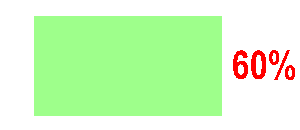
| slow run | 60-80% | 6:15 - 8:20 minutes/km | |
| difficult to run | 20-60% | 8:20 - 25:00 minutes/km | |
| fight | 0-20% | >25:00 minutes/km |
COLOUR
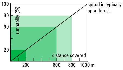
The basic principle is as follows:
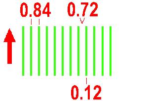
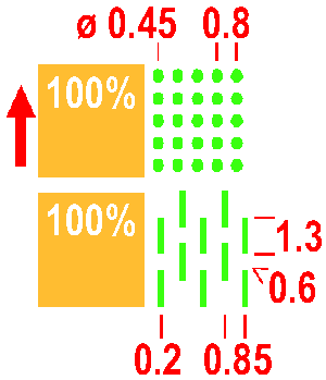
Runnability in forest is divided into 4 categories according to running speed. If speed through typically open runnable forest is, for example, 5 min/km, the following ratios apply:
| open forest | 80-100% | 5 - 6:15 minutes/km |
| slow run | 60-80% | 6:15 - 8:20 minutes/km | |
| difficult to run | 20-60% | 8:20 - 25:00 minutes/km | |
| fight | 0-20% | >25:00 minutes/km |
 | 401 Open land Cultivated land, fields, meadows, grassland, etc. without trees, offering easy running. If yellow coloured areas becomes dominant, a screen (75%) instead of full yellow may be used. Colour: yellow. |
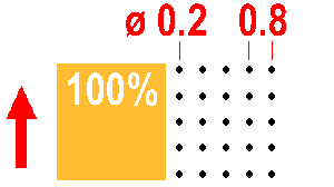
 | 402 Open land with scattered trees Meadows with scattered trees or bushes, with grass or similar ground cover offering easy running. Areas smaller than 10 mm2 at the maps scale are shown as open land (401). Individual trees may be added (418, 419, 420). If yellow coloured areas becomes dominant, a screen (75%) instead of full yellow may be used. Colour: yellow (20 lines/cm). |
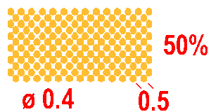
 | 403 Rough open land Heath, moorland, felled areas, newly planted areas (trees lower than ca. 1 m) or other generally open land with rough ground vegetation, heather or tall grass. Symbol 403 may be combined with symbols 407 and 409 to show reduced runnability. Colour: yellow 50% (60 lines/cm). |
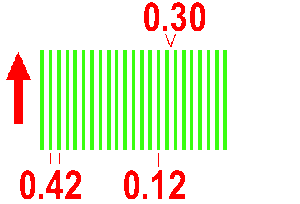
 | 404 Rough open land with scattered trees Where there are scattered trees in rough open land, areas of white (or green) should appear in the tone. Such an area may be generalised by using a regular pattern of large white dots in the yellow screen. Areas smaller than 16 mm2 in the maps scale are shown as rough open land (403). Individual trees may be added (418, 419, 420). Colour: yellow 70% (60 lines/cm), white 48.5% (14.3 lines/cm). |
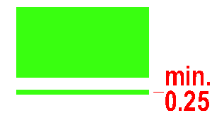
 | 405 Forest: easy running Typically open runnable forest for the particular type of terrain. If no part of the forest is runnable then no white should appear on the map. Colour: white. |
 | 406 Forest: slow running An area with dense trees (low visibility) which reduces running to ca. 60-80% of normal speed. Colour: green 30% (60 lines/cm). |
 | 407 Undergrowth: slow running An area of dense undergrowth but otherwise good visibility (brambles, heather, low bushes, and including cut branches) which reduces running to ca. 60-80% of normal speed. This symbol may not be combined with 406 or 408. Colour: green 14.3% (11.9 lines/cm). |
 | 408 Forest: difficult to run An area with dense trees or thicket (low visibility) which reduce running to ca. 20-60% of normal speed. Colour: green 60% (60 lines/cm). |
 | 409 Undergrowth: difficult to run An area of dense undergrowth but otherwise good visibility (brambles, heather, low bushes, and including cut branches) which reduces running to ca. 20-60% of normal speed. This symbol may not be combined with 406 or 408. Colour: green 28.6% (23.8 lines/cm). |
 | 410 Vegetation: very difficult to run, impassable An area of dense vegetation (trees or undergrowth) which is barely passable. Running reduced to ca. 0 - 20% of normal speed. Colour: green 100%. |
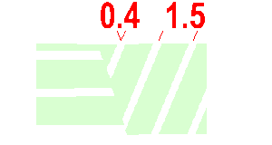 | 411 Forest runnable in one direction When an area of forest provides good running in one direction but less good in others, white stripes are left in the screen symbol to show the direction of good running. Colour: green, white. |
 | 412 Orchard Land planted with fruit trees or bushes. The dot lines may be orientated to show the direction of planting. If yellow coloured areas becomes dominant, a screen (75%) instead of full yellow may be used. Colour: yellow and green 25% (12.5 lines/cm). 413 Vineyard The green lines may be orientated to show the direction of planting. If yellow coloured areas becomes dominant, a screen (75%) instead of full yellow may be used. Colour: yellow and green. |
 | 414 Distinct cultivation boundary The boundary of cultivated land when not shown with other symbols (fence, wall, path, etc.) is shown with a black line. A permanent boundary between different types of cultivated land is also shown with this symbol. Colour: black. |
 | 415 Cultivated land Cultivated land which is seasonally out-of-bounds due to growing crops may be shown with a black dot screen. Colour: yellow 100%, black 5% (12.5 lines/cm). |
 | 416 Distinct vegetation boundary A distinct forest edge or very distinct vegetation boundary within the forest. Colour: black. |
 | 417 Indistinct vegetation boundary Indistinct boundaries between areas of green, yellow or white are shown without a line. The edge of the area is shown only by the change in colour or dot screen. |
 | 418, 419, 420 Special vegetation features Symbols 418, 419 and 420 can be used for special small vegetation features. The definition of the symbol must be given in each case in the map legend. Colour: green. |


