NORWAY

countries - history of o-mapping
Suggestions, amendments warmly welcome: László Zentai - editor
countries - history of o-mapping
Suggestions, amendments warmly welcome: László Zentai - editor
"Oppsal IF o-kart no. 1"
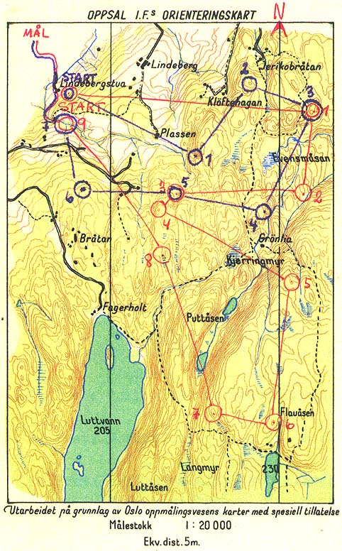
30 April 1950 that all changed. The first map specifically made for orienteering was used. Knut Valstad had competed internationally in Denmark, Sweden, and Finland, and with this map he used the best from all the countries.As the invitation to the event states: "With this competition we want to try some of the different experiences learned from Denmark, Finland and Sweden. The whole affair will be different from our usual competitions. The controls will be at details normally not found on our maps. The controls will be placed like they usually do in Denmark. The map has a scale normally used in Finland. We believe this will be good training for international events, and a fun and interesting experience change in the sport of orienteering."
The scale of the map was 1:20.000, with four colours; light green forest and white fields, but otherwise as today's maps. The base map was Oslo city maps in the scale 1:5000, with 5 meter contours. The map was much more detailed than anything used in Norway up to that time. As the PM stated "This is all based on fine navigation, the control (control flag) will be found by the ability to navigate, not by luck or searching."
The idea of special maps for orienteering caught on rapidly. The year after another orienteering map was made in Oslo. In 1952 four maps were made, and four or five more maps each year for the rest of the fifties. There were usually several events on each map, so the number of events on orienteering maps increased even more than the number of maps.
Photogrammetry was not commonly used in mapping in Norway before WW2. The maps were measured and triangulated from the ground. In the fifties photogrammetry became commonly used for mapping. Orienteers rapidly seized the opportunity to improve their base maps. During thewinter '54-'55 Svein Sjonnesen made the first special Photogrammetry for an orienteering map. About the same time Brynjulf Engen also made specially plotted base maps for orienteering maps. Both Sjonnesen and Engen were employed by mapping companies in Oslo.
Jorgen Loken from Kongsberg saw the enormous possibilities in stereogrammetry and moved to the Netherlands to learn the technique. When he moved back he started to make base maps that were much more detailed than anything seen before. The maps contained so much information that a completely new orienteering technique was needed. The map was so detailed and accurate that the compass was hardly needed anymore, the runners could just read the maps. The Norwegian orienteers mastered this technique, and won everything ( 7 among the 8 first in the men's class).
After this probably biggest home advantage in any sport the Swedish year book wrote: " In Norway ... they have succeeded in making maps that are so excellent, particularly with respect to the contours, the nothing resembling them are available to orienteers anywhere in the world. These maps are the ideal internationally. .... The IOF congress in Bulgaria last year (1965) adopted the Norwegian maps as the standard for the coming world championships, and as the norm for orienteering maps internationally. ... The Norwegian maps must be the norm, even by us. Every cloud has a silver lining. In this case the disaster in the Nordic Championships 1965 could be the start for a new and brighter future for Swedish orienteering."
The map lacked to green colour, but otherwise the colours and symbols were more or less identical with todays maps (save for some small adjustments of line widths).
Bernt O. Myrvold, 1994.