Final Remark
Together this material has an enormous scope and depth, and I am really glad this study was undertaken. It is a problem that it is in Dutch only, but at least I removed that handicap partially by reporting here on the material.
Final Remark |
||||
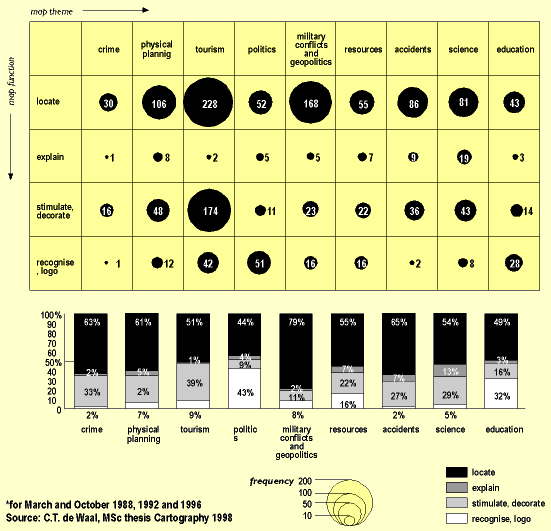
| It is now left to me to show you something of the complexity of this MSc thesis, which got a bit out of hand, while the author really learned how to use all these statistical packages. Figure 8 relates map themes to map functions for all 5 newspapers analysed. Politics, or rather election results apparently need maps only for their logo function; the explanatory is best developed in science maps, which makes sense. The locating function is best developed in crime maps and maps of military conflicts and geopolitics. |
||||
|
||||
| Figure 8 - Newspaper map themes vs map functions |
||||
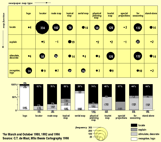
| Figure 9 relates newspaper map types to map functions. Part of the contents is a bit obvious; logo’s of course are meant for recognition, locator maps are meant for locating purposes. But apart from those open doors, it is interesting to see that tourist maps have as much a locating as a stimulating function, and the same goes for other maps with an inducing nature. |
||||
|
||||
| Figure 9 - Newspaper map types vs map functions |
||||
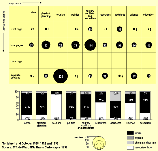
| Finally, I will present a matrix of newspaper map themes and their location within the newspaper: it is this figure that shows best the selection of the different map themes for different locations in the newspaper. This illustration provides also the best cartographic characterisation of Dutch newspapers. For tourist maps, go for the additional sections; for physical planning maps and maps on military conflicts go to the inner pages of the first section; accidents will be shown first on the front page, and the inner section might have some more detailed views. Together this material has an enormous scope and depth, and I am really glad this study was undertaken. It is a problem that it is in Dutch only, but at least I removed that handicap partially by reporting here on the material. |
||||
|
||||
| Figure 10 - Matrix of map themes vs newspaper selection for all 5 newspapers | ||||
|
|
||||