| XII. 18. | Papp Éva PhD (Australian National University, Papp Geophysical Services) gives a paper at the Department, "Geophysics in shallow water exploration - the Australian experience" | |
| XII. 17. | Conference on the occasion of the 70th birthday of Prof. Detrekői Ákos at the Budapest University of Technology and Economics. Klinghammer István gives a paper, "The beginnings of thematic cartography" | |
| XII. 11. | Undergraduate student research – presentation at the Department: Zsoldi Katalin: The high days of Russian cartography (Introduction and to and description of Russian cartography in the 18th century). Supervisor: Török Zsolt Ungvári Zsuzsanna: Making globes by digital transformation of projections. Supervisor: Gede Mátyás |
|
| XII. 10. | Lázár Colloquium Márton Mátyás: On the maps of Reguly 190 years after his birth Turczi Vanda: Cartographic testing of the European Flood Directive on the Midle Loire and Cher Rivers |
|
| XII. 7. | Colonel Buga László, invited lecturer of the Department, received the title honorary associate professor from the rector of the university | |
XI. 27. |
Zentai László gives a paper in Curitiba, Brazil at the UFPR (Universidade Federal do Paraná). |
|
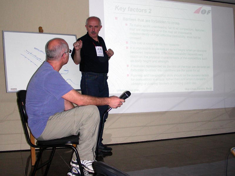
XI. 25-27. |
Zentai László gives a three-day map revision training in Curitiba, Brazil organized by the IOF (International Orienteering Federation) and CBO (Confederação Brasileira de Orientação). |
|
XI. 20. |
Scientific session in the Bocskai István Secondary School in Szerencs organized to honour the 75 year old Prof. Frisnyák Sándor. A paper was given by Klinghammer István, academician: "The history of thematic cartography" | |
XI. 19. |
Open Day at the Faculty of Informatics of the university. Papers from the Department: |
|
XI. 19. |
Vesta-GIS workshop in Székesfehérvár in the Land Management and Geoinformation Knowledge Centre of the Faculty of Geoinformatics of the West Hungarian University. |
|
XI. 18. |
Memorial meeting of the Geoinformation Service of the Hungarian Army and the Non-profit Cartographic Company of the Ministry of Defence on the occasion of completing the 1 : 25 000 military topographic mapping (1952--1959) 50 years ago. Engineer colonel Tóth László (head of MH GEOSZ) and Engineer colonel Buga László (managing director) emphasized the importance of the survey and remembered the participants of the topographic mapping. |
|
XI. 15-21. |
24the International Conference of Cartographers in Santiago de Chile. |
|
XI. 13. |
„The Week of Science in the College of Dunaújváros – Interdisciplinary conference to honour the Day of Hungarian Science and the European Year of Creativity and Innovation 2009". Prof. Márton Mátyás gave a presentation, "on the research projects at the Department, "Virtual Globes Museum"– http://vgm.elte.hu”. |
|
XI. 12-13. |
Fény-Tér-Kép (Light–Space–Image) conference in Dobogókő. Participants and presenters from the Department: Elek István, Mészáros János (PhD student). Papers: Mészáros János – Timár Gábor: The coordinate system and georeferencing of river regulations (Danube mapping, Lányi Sámuel's maps of the Tisza River. Elek István – Giachetta Roberto – Máriás Zsigmond: Developing a digital map library at ELTE |
|
XI. 9. |
||
XI. 5. |
||
XI. 4-5. |
International conference: Radó Sándor was born 110 years ago. Papers given by the Department: |
|
| XI. 1. | Lenkei Ákos, PhD student got a three-months CEEPUS scholarship to Olomouc | |
X. 16. |
Márton Mátyás and Jesús Reyes represented the Department at the conference, "Changing Earth, changing society, changing learning" organized by the Department of Geography of Eszterházy Károly College in Eger. In the section, „New ways of learning – new tools in geography education”, they gave presentations: „Popularizing cartography in Hungarian” (Jesús Reyes) and „Virtual Globes Museum – a tool available by Internet" (Márton Mátyás) |
|
X. 11-23. |
Visit to the Department by Ana María Garra (teacher of the „Septimio Wlash” Catholic University, secretary of the Argentinean Cartographic Centre) in the framework of an intergovernmental agreement on science and technology. She had consultations on the joint projects with the Hungarian partners and attended the central event of the International Day of White Stake organized in the office of the Hungarian Association of Blind and Visually Handicapped. Here, Rohonczi Anita, a project partner, presented her school atlas prepared for the visually handicapped. |
|
| X. 6. | The staff of the Department gives several papers at the workshop on the Kiepert globes in the University Library of the University of Szeged: Klinghammer István: The history of globe making in Hungary Török Zsolt: Globes at a glance – an overview of the international history of globes Márton Mátyás: Kiepert globes in the Virtual Globes Museum Gede Mátyás: The technological background of digitizing globes |
|
X. 1-30. |
Miklós Réka and Groos Boróka, first year MSc students of tourism and regional development at the Babes-Bolyai University (Cluj, Romania) spend several weeks in the autumn semester of the 2009/2010 academic year at the Department supported by the ministerial scholarship of the Hungarian Ministry of Education and Culture and Balassi Institute. Their supervisor: Török Zsolt. |
|
| IX. 29. | 5vös 5 km run race | |
| IX. 25. | Open Day at the Faculty of Science and The Night of Scientists | |
| IX. 15. | Our first student, Hajdu Tamás goes to study in Vienna with a CEEPUS grant. | |
| IX. 10. | Foreign Erasmus students arrive at the Department. Adriana Cuesta (University of the Basque Country, Spain) will spend one semester here, while Monica Macedo Santos (University of Minho, Portugal) will stay with us for two semesters. | |
| IX. 1. | Györffy János was appointed Vice-Dean of the Faculty of Informatics. Márton Mátyás received the appointment of professor by Sólyom László, president of Hungary. |
|
| VIII. 18. | Gercsák Gábor and Márton Mátyás represented the Department at the meeting of Hungarian and Slovakian experts on the preparation of a project on the study of the water basin of the Ipoly river. Zentai László opened the exhibition, "The History of Orienteering and Maps in Miskolc and in the Region" in the University of Miskolc. The exhibition was organized by Hegedüs Ábel and Bánfi Róbert, researchers (cartographers by training) of the MoD Institute and Museum of Military History. |
|
| VII. 12-17. | Török Zsolt represented the Department at the 23rd International Conference on the History of Cartography in Copenhagen | |
| VI. 29-30. | MSc state exams | |
| VI. 22-26. | BSc state exams | |
| VI. 15. | Prof. Klinghammer István was elected chairman of the Economic Council of the university | |
| VI. 9-10. | Zentai László participated in the ceremonial meeting of the International Cartographical Association in Berne held on the occasion its founding 50 years ago. | |
| VI. 5. | Török Zsolt gave the Malcolm Young paper, “Francesco Rosselli and Early Map Printing” in the East India Club at the annual meeting of the International Map Collectors’ Society (IMCoS) in London. He was invited by the Society. Török Zsolt received the Helen Wallis Award of 2009 of the International Map Collectors’ Society (IMCoS) in London. |
|
| VI. 4. | Uriel Elzegua, an Erasmus exchange student from the Basque University defended his degree thesis, “Making thematic maps in MapInfo: Human heritage in the European Union” | |
| V. 25. | María Luisa Palanques Salmerón, a teacher from the Basque University, gave a paper at the department, "Research project for the digital inventory of the old maps of Alava county " (Proyecto de investigacion para el inventario de la cartografia historica de Alava) | |
| V. 21. | Ringhofer János, honorary associate professor of the Department, passed away. | |
| V. 12-21. | Zentai László, held a one-week workshop in Tehran organized by the Commission on Education and Training of the ICA and the National Cartographic Center of Iran. His co-teacher was Guszlev Antal, a former student and PhD student of the Department. | |
| V. 7. | Faculty Research Award to the Cartographic University Research Team: Dr. Elek István associate professor, Dr. Fekete István associate professor, Dezső Balázs PhD student, Gede Mátyás assistant professor, Giachetta Roberto research student, Máriás Zsigmond PhD student, Dr. Márton Mátyás associate professor, Szendrei Rudolf PhD student | |
| V. 5. | 5vös 5 km race | |
| IV. 30. | Temenoujka Bandrova, a teacher from the Department of Cartography and Photogrammetry, University of Construction and Geodesy, Sofia, gave a paper, “Cartographic Visualization of Natural Risks and Disasters". The Department also hosted Milan Konecny, the former vice-president of the International Cartographical Association. | |
IV. 24-25. |
Descriptio Transylvaniae conference in Cluj-Napoca (Kolozsvár): |
|
IV. 8. |
National Undergraduate Research Conference in Szombathely. In the Section of Physics, Earth Sciences and Mathematics, Tóth Bettina-Való Adrienn’s paper, “Geoinformatics in the service of safeguarding the cultural heritage (The database of geographical names of old maps)” was awarded the 7th place, while the paper by Lukovszki Viktor-Kovács Gábor, “Web catalogue of maps supported by geoinformatics” received the 4th place and was awarded the special prize of the Hungarian State Geological Institute. |
|
III. 27. |
||
III. 23-27. |
JoséJesús Reyes Nunez visited the Institute of Topography, Geodesy and Mapping of the Technical University of Madrid (UPM). He had a class on geovisualization and gave a paper, “Cartografía Temática: desde sus orígenes hasta el presente". His visit was supported by the Erasmus agreement signed by the Department and the UPM. He visited several other institutions (National Institute of Geography, Autonomous University of Madrid, the University of Alcalá de Henares) to prepare further cooperation. |
|
III. 20. |
Exhibition and Awards of the competition, “Beautiful Hungarian Map”. |
|
III. 18. |
Török Zsolt opens the exhibition “Waters and Men” in the Danube Museum in Esztergom. |
|
II. 20. |
||
II. 15-17 |
Central and East European Conference of Cartographers in Vienna. The Department was represented by Gede Mátyás, Kovács Béla, Jesús Reyes, Zentai László, Kovács Gábor - student, Turczi Vanda – PhD student, who gave several papers:
Jesús Reyes and Zentai László participated in the conference also as section chairs and the moderators of panel discussions. |
|
| II- | Our outgoing Erasmus students: Duna Gábor Dávid, Orléans, France; Hajdu András, Karlsruhe, Germany Incoming Eramus students: Uriel Elgezua Fernández (Universidad del Pais Vasco/ Euskal Herriko Unibertsitatea) |
|
| I. 30. | Open Day at the Faculty of Science | |
| I. 27. | State exams | |
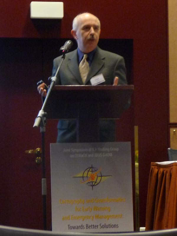
| I. 19-22. | Zentai László participated in the conference, “Early Warning and Disaster Management” in Prague. He gave a paper, "Early warning and emergency management maps of Lake Balaton, Hungary" and participated in the meeting of the ICA Commission on Teaching and Training. | |
| I. 15. | David Fraser (RMIT University, Melbourne), chairman of the ICA Commission on Education and Training gave a lecture at the Department with the title, "Research Activities and Mapping Projects in the School of Mathematical and Geospatial Sciences" |